A cold front and upper-level trough system is bringing cold, wet weather and spring snowfalls to South Africa.
Our weather models have shown substantial strengthening of this storm system with 40-50cm+ of snow expect across much of Lesotho and the Drakensberg mountain range.
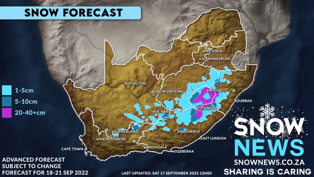
The models indicate light snowfall, 1-5+ cm, possible over the mountains of the Western Cape and mountainous areas in the Karoo on Sunday and then spreading to the north-eastern high ground of the Eastern Cape.
Rare Thundersnow storms are also possible on Monday into Tuesday over the Eastern Cape, Drakensberg (central and northern), Southern Drakensberg, Underberg, KZN Midlands & Lesotho.
Lesotho is expected to see SIGNIFICANT amounts of snowfall with 40-50cm+ possible over most of the Lesotho mountains, Sani Pass, Afriski, Tiffendel and most of the Drakensberg mountain range.
Ground snow also is also highly possible at the foothills of the Southern Drakensberg (Underberg/Himeville) and most of the Maloti-Drakensberg Park and across parts of the KZN midlands stretching across the escarpment into extreme Southern Mpumalanga.
Ground level snow also possible across the South-Eastern Free State. If this forecast stays on track Bloenfontein, Van Reenen’s, Harrismith and Bethlehem are just some towns that could possibly see snow with Newscastle KZN also standing a chance of seeing snowfalls.
The Snow News team will keep you updated.
Make sure to send us your photos on our Facebook page or via Whatsapp 078-503-4693
#snownews #snowmap #winter #snowinafrica
Make sure to follow our Facebook Page at https://web.facebook.com/SnowNews
Join our Free Telegram group at https://t.me/snownewsZA
Contact us on snow@snownews.co.za for any advertising enquiries.
Watch out for our new FREE snowfall accommodation directory coming soon.
snownews #snowtember #snowinseptember #springsnow #snowinafrica